
Rick Gordon’s Weather Watch
Follow our YouTube channel here.
Today’s Outlook
It will be sunny, breezy, and more humid today. There is a possible danger of dehydration and heatstroke while doing strenuous activities in the record heat (record high of 89° in 1949). The high temperature today is expected to reach 95° (feels like 97°). Winds will be from the west-southwest at 10-20+ mph.
Feels Like Summer
Get ready for a taste of summer! Today and tomorrow, temperatures are set to soar to sizzling July and August levels.temperatures are set to soar to sizzling July and August levels.
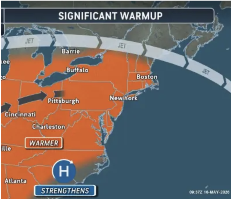
Temperatures are expected to rise into the 90s, a significant change as sustained warmth has been uncommon this spring. While hot-weather enthusiasts may welcome the shift after experiencing chilly conditions and needing to wear long sleeves and jackets, the sudden temperature increase could be jarring. Additionally, the rise in humidity may make it challenging for some sensitive individuals to adapt to the 30-degree temperature change. Both Tuesday and Wednesday will produce record high temperatures!
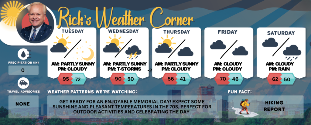
Today: Some sun, breezy, & more humid; possible danger of dehydration and heatstroke while doing strenuous activities with record heat. (Record 89 1949). High 95 (feel like 97) Winds: WSW 10-20+ mph
Tonight: Spot evening thunderstorms, very warm, & humid. Low 72 Winds: SW 5-10 mph
Wednesday: Windy, hot, and humid with sun and clouds; afternoon thunderstorms may bring hail and damaging winds. The high temperature will be 90, breaking the record of 86 set in 2003. It will feel like 92. Winds: WSW at 15-20+ mph.
Wednesday night: Partly cloudy, cooler, and less humid. Low 50 Winds: NW 10-15 mph
Thursday: Cool with some sun & clouds. High 67 Winds: NW 5-15 mph Thursday night: Partly cloudy & chilly. Low 41 Winds: NNW 5-10 mph
Friday: More clouds than sun & nice. High 70 Winds: NW 5-10 mph
Friday night: Partly cloudy & chilly. Low 46 Winds: Light & Variable
Saturday: Lots of clouds. High 62 Winds: S 5-15 mph
Saturday night: Periods of rain. Low 50 Winds: SE 5-10 mph
Weather Patterns We’re Watching
Get ready for an enjoyable Memorial Day! Expect some sunshine and pleasant temperatures in the 70s, perfect for outdoor activities and celebrating the day.
Get Out!

Elevations for summits above 4,000 feet in Northern New Hampshire today: The summits will be obscured, with a possibility of afternoon showers. High temperatures are expected to reach the lower 70s, while elevations above 5,000 feet may see highs in the mid-60s. West winds will range from 25 to 35 mph, with gusts potentially reaching up to 70 mph. The chance of rain is 50 percent.
Elevations between 2,500 and 4,000 feet in Northern New Hampshire today: Summits are obscured with a chance of afternoon showers. Highs will be in the mid-70s, accompanied by west winds at 10 to 20 mph, with gusts up to 50 mph. There is a 50 percent chance of rain.