Weather Watch with Rick Gordon
Below: Watch your weather outlook via YouTube, delivered in two minutes.
Wednesday’s Weather
Today will be humid with highs in the mid-70s as a cold front approaches look for afternoon and evening thunderstorms that could bring gusty wind and some small hail.

5-Day Outlook, Sept. 13–17
Today: Cloudy and humid with afternoon thunderstorms with gusty wind and hail. High 74 Winds: S 5-10 mph
Tonight: Evening thunderstorms with some clearing late. Low 62 Winds: WSW 5-10 mph
Thursday: Mostly sunny and less humid. High 75 Winds: NW 5-10 mph
Thursday night: Clear & comfortable. Low 53 Winds: NW 5-10 mph
Friday: Cool & breezy with a mix of sun & clouds. High Near 70 Winds: NNW 10-15+ mph
Friday night: Clouding up with some rain late. Low 59 Winds: NNE 10-15 mph
Saturday: Some wind and rain (1-2″) from Hurricane Lee; the greatest impacts along the coast. High 67 Winds: NNW 15-25 with some gusts to 40 mph
Saturday night: Early rain (.25″) with some clearing late. Low 58 Winds: NW 10-20 with gusts to 40 mph
Sunday: Mix of sun & clouds, breezy and warmer. High 77 Winds: NW 10-15+
Sunday night: Partly cloudy. Low 56 Winds: WNW 5-10 mph
Hurricane Lee Update
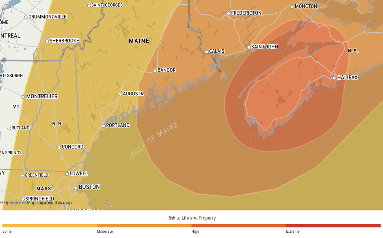
The level of risk due to high winds, flooding rain, surge, and tornado potential for an active tropical system.
Hampton Beach, NH impacts
START 9 a.m. Saturday, 9/16
END 9 a.m. Sunday, 9/17
FORECASTED IMPACTS
Peak Sustained Winds 27 mph
Peak Wind Gusts 50 mph
Total Rainfall 1-2 inches
Building offshore swells, coastal wave action, beach erosion, and rip currents from today into this weekend.
Weather Patterns We’re Watching
Hurricane Lee’s direct impacts Saturday into Sunday morning will be rough surf, rip currents, and gusts to 50 mph along coastal New Hampshire.
 Hiking Report/White Mountains Weather
Elevations for summits above 4,000 feet in Northern New Hampshire Today: Summits obscured. Rain. A chance of thunderstorms in the afternoon. Highs in the upper 50s. Southwest winds 10 to 20 mph. Chance of rain 90 percent.
Elevations between 2,500 and 4,000 feet in Northern New Hampshire Today: Summits obscured. Rain. A chance of thunderstorms in the afternoon. Highs in the lower 60s. South winds 10 to 15 mph with gusts up to 25 mph. Chance of rain 90 percent.
BEACH FORECAST
Weather: Cloudy. Areas of fog. A chance of showers and a slight chance of thunderstorms.
UV Index: Low.
Thunderstorm Potential: Moderate. Implies that thunderstorms are possible.
High Temperature: In the lower 70s.
Winds: Southeast winds 5 to 10 mph.
Surf Height: Around 3 feet.
Water Temperature: 68 degrees.
Rip Current Risk: Moderate. A moderate risk of rip currents implies that individuals planning to enter the surf should check with local beach patrols first. Be sure to swim within sight of a lifeguard, and never alone or at night. Always have a flotation device with you in the water.
 View on Lake Winnipiseogee (1828) by American painter Thomas Cole
Lake Forecast
Southeast winds around 5 mph. Waves around 1 foot. Cloudy. Areas of fog in the morning. A chance of showers in the morning, then rain likely with a chance of thunderstorms in the afternoon. Humid with highs in the lower 70s. Chance of rain 70 percent. The lightning threat is moderate, which implies that thunderstorms are possible. The water temperature is 73 degrees.

