
Rick Gordon’s Weather Watch
Follow our YouTube channel here.
Today’s Outlook
Haze + SSW flow brings in warmer, moisture‑rich air. Dew points rising push the “feels like” into the low 90s. Evening pop‑up storm chance comes from that added humidity + late‑day instability.
The first day of Astronomical Summer in 2026 is only 12 days away!
The first day of astronomical summer in the Northern Hemisphere in 2026 is Sunday, June 21, 2026, at 4:24 AM. This moment marks the summer solstice, when the Sun reaches its highest and northernmost point in the sky, and the Northern Hemisphere is tilted most directly toward the Sun.
Weather outlook for the first day of Summer is for some sunshine and a high of 81 degrees.
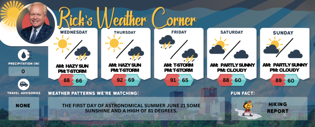
Today: Hazy sunshine, more humid, and very warm with a stray thunderstorm by evening. High 88 (feel like 92) Winds: SSW 5-10 mph
Tonight: Mostly cloudy, warm and humid with a couple of showers and a thunderstorm. Low 66 (feel like 68) Winds: SSW 5-10 mph
Thursday: Hot & muggy with some sun and a spot afternoon thunderstorm; storms can bring flooding downpours and localized damaging wind gusts. High 92 near record of 94 set in 2017 (feel like 95) Winds: WNW 5-15 mph
Thursday night: Spot evening thunderstorm, warm, and humid. Low 69 (feel like 70) Winds: Light & Variable
Friday: Some sun, hot, and muggy with late afternoon thunderstorms. High 91 (feel like 96) Winds: E 5-10 mph
Friday night: Some evening thunderstorms, warm, and humid. Low 65 (feel like 68) Winds: E 5-10 mph
Saturday: Some sun, very warm, & turning less humid. High: 88 Winds: WNW 5-10 mph
Saturday night: Partly cloudy & comfortable for sleeping. Low 60 Winds: W 5-10 mph
Sunday: Lots of sun & very warm. High 89 Winds: WSW 10-15 mph
Sunday night: Increasing clouds with some showers late. Low Near 60 Winds: SW 5-10 mph
Weather Patterns We’re Watching
The first day of Astronomical Summer June 21 some sunshine and a high of 81 degrees.
Get Out!
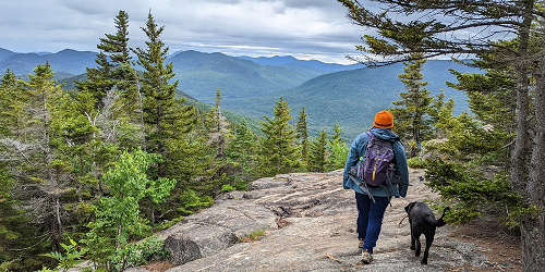
Take a Hike
Summits above 4,000 feet: Mostly cloudy in the morning, then summits in and out of clouds. A chance of showers and thunderstorms in the afternoon. Highs around 70…except in the lower 60s at elevations above 5000 feet. Southwest winds up to 10 mph with gusts up to 25 mph. Chance of rain 50 percent. Elevations between 2,500 and 4,000 feet: Mostly cloudy in the morning, then summits in and out of clouds. A chance of showers and thunderstorms in the afternoon. Highs in the mid 70s. Light and variable winds. Chance of rain 50 percent.
Hit the Beach
Hampton & Rye Beach Weather: Weather: Mostly sunny until 2 PM, then mostly cloudy. Thunderstorm Potential: None. High Temperature: In the lower 80s. Winds: Southwest winds 5 to 10 mph. Surf Height: Around 2 feet, subsiding to around 1 foot in the afternoon. Rip Current Risk: Low. Tides: Hampton Beach High 8.0 feet (MLLW) 07:11 AM. Low 0.7 feet (MLLW) 01:36 PM. Ocean Temperature: 55 degrees. According to the USCG, when the water temperature is below 60 degrees, an average submerged person could lose dexterity within minutes and be unable to perform simple tasks such as buckling a life jacket or operating a radio.
Jump in a Lake
Weirs Beach: Southwest winds around 5 mph. Waves around 1 foot. Partly sunny. A chance of showers with a slight chance of thunderstorms in the afternoon. Highs in the mid 80s. Chance of rain 40 percent. Water temperature 62 degrees.