
Wednesday’s Weather

5-Day Outlook Dec. 1 – Dec. 5
Weather Alert
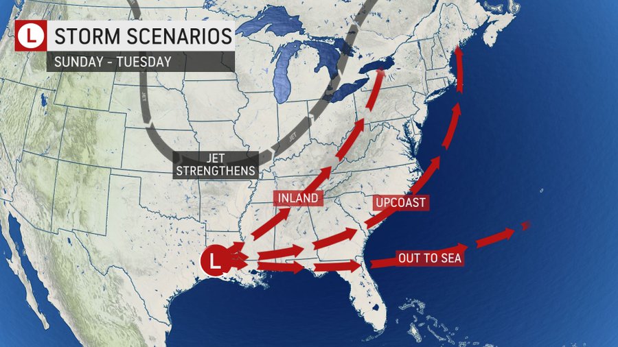
A potential storm will produce rain early next week. Below are the storm track scenarios for Monday. It now looks like the storm will take an inland track, which means rain on Monday.
Weather Patterns We’re Watching
Our next chance of snow will be Wednesday of next week.
Your favorite ski areas estimated opening dates are listed below
Open: Loon Mt. and Bretton Woods
Friday, December 3 – Attitash Mountain Resort, Cannon Mountain, Wildcat Mountain Friday,
December 10 – Gunstock Mountain Resort Saturday
December 11 – Black Mountain, Crotched Mountain Friday
December 17 – Dartmouth Skiway, King Pine Ski Area Sunday
December 26 – Abenaki Ski Area
TBD – Cranmore Mountain Resort, McIntyre Ski Area, Mount Sunapee Resort, Pats Peak, Ragged Mountain Resort, Waterville Valley Resort, Whaleback
Forecast for the White Mountains
- Summits above 4,000 feet in Northern New Hampshire. Today: Summits obscured. A chance of snow showers in the morning. Highs in the lower 20s. West winds 20 to 30 mph… except west 35 to 45 mph at elevations above 5000 feet. Chance of snow 40 percent. Wind chill values as low as 17 below.
- Elevations between 2,500 and 4,000 feet in Northern New Hampshire. Today: Summits obscured. A chance of snow showers in the morning. Highs in the upper 20s. West winds 20 to 30 mph. Chance of snow 50 percent. Wind chill values as low as 1 below in the morning.

Be an official Ink Link Weather Spotter!
Rick Gordon could use your help. If you are interested in becoming a local weather spotter (all locations around NH) contact Rick at gordonwx@comcast.net and he’ll walk you through the process!