
Wednesday’s Weather
We have started our descent to below normal temperatures yesterday, with highs today expected to only reach around 50. This will be the general theme for the rest of the workweek as well.
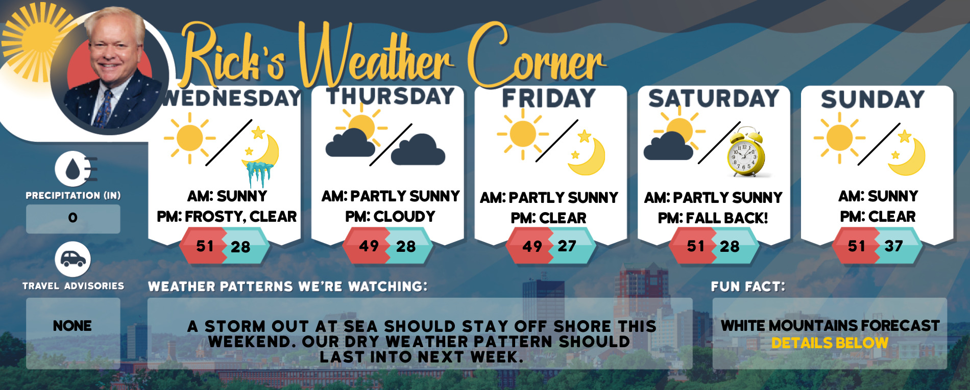
5-Day Outlook Nov. 3 – Nov. 7
Today: Mostly sunny High 51 Winds: WNW 5-10 mph
Tonight: Clear & cold with a frost and freeze Low 28 Winds: Light & Variable
Thursday: Cold with a mix of sun & clouds High 49 Winds: Light & Variable
Thursday night: Partly cloudy & cold Low 28 Winds: Light & Variable
Friday: Mostly sunny & cold High 49 Winds: NW 5-10 mph
Friday night: Clear & cold Low 27 Winds: Light & Variable
Saturday: Mostly sunny & cold High 51 Winds: Light & Variable
Saturday night: (Put clocks back 1 hour) Clear & cold Low 28 Winds: Light & Variable
Sunday: Mostly sunny & cold High 51 Winds: Light & Variable
Sunday night: Mainly clear Low 37 Winds: Light & Variable
Weather Patterns We’re Watching
A storm out at sea should stay off shore this weekend. Our dry weather pattern should last into next week.
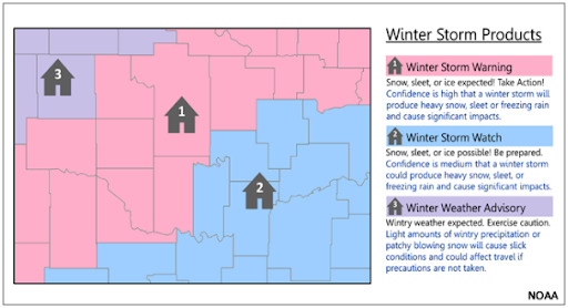
Winter Weather Preparedness Week
What’s the difference between a Winter Storm Watch, Winter Storm Warning and Winter Weather Advisory?
Forecast for the White Mountains
- Summits above 4,000 feet in Northern New Hampshire. Today: Summits obscured. Highs around 30. Northwest winds 25 to 35 mph with gusts up to 45 mph. Wind chill values as low as 3 below in the afternoon.
- Elevations between 2,500 and 4,000 feet in Northern New Hampshire. Today: Cloudy. Highs in the mid-30s. Northwest winds 15 to 25 mph. Wind chill values as low as 11.

Be an official Ink Link Weather Spotter!
Rick Gordon could use your help. If you are interested in becoming a local weather spotter (all locations around NH) contact Rick at gordonwx@comcast.net and he’ll walk you through the process!