
Rick Gordon’s Weather Watch
Follow our YouTube channel here.
Today’s Weather
Start your day with morning rain and a thunderstorm measuring about 0.35 inches. As you move into the afternoon, expect some sun to make a glorious comeback, brightening the skies! With a high of 63 degrees and a refreshing breeze from the south-southwest at 10 to 15 mph, it’s shaping up to be an interesting day. Enjoy the mix of weather!
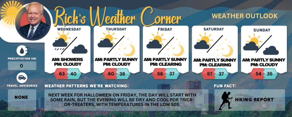
Today: Morning rain (.35″) & a thunderstorm with afternoon sunshine. High 63 Winds: SSW 10-15+ mph
Tonight: Mainly clear. Low Around 40 Winds: Light & Variable
Thursday: Breezy with some sun & clouds. High 60 (feel like 57) Winds: SW 15-20 mph
Thursday night: Clear to partly cloudy. Low 38 Winds: NW 5-10 mph
Friday: Cool sunshine. High 58 Winds: W 5-10 mph
Friday night: Clearing and cold. Low 37 Winds: Light & Variable
Saturday: Mostly sunny & cool. High 57 (feel like 53) Winds: NW 5-15+ mph
Saturday night: Mainly clear and cold. Low 37 Winds: Light & Variable
Sunday: Cool with some sun & clouds. High 54 Winds: NW 5-10 mph
Sunday night: Some clouds & cold. Low 35 Winds: Light & Variable
A chill reminiscent of November is approaching!
A new storm will bring rain and a thunderstorm this morning, followed by cooler temperatures in the 50s by Friday lasting into the weekend, making it feel more like mid-November than October.
Weather Patterns We’re Watching
Next week for Halloween on Friday, the day will start with some rain, but the evening will be dry and cool for trick-or-treaters, with temperatures in the low 50s.
Get Out!
Elevations for summits above 4,000 feet in Northern New Hampshire today: Rain showers with highs in the low 40s. South winds at 10 to 20 mph, gusting up to 50 mph. Rain chance close to 100 percent.
Elevations between 2,500 and 4,000 feet in Northern New Hampshire today: Showers are expected with highs in the upper 40s. South winds will range from 10 to 15 mph, with gusts reaching up to 35 mph. The chance of rain is nearly 100 percent.