
Rick Gordon’s Weather Watch
Follow our YouTube channel here.
Today’s Weather
Enjoy a delightful day, with mostly sunny skies setting the scene! With temperatures reaching a pleasant high of 86, it’s the perfect weather to get outside. Plus, gentle winds blowing in from the WSW at 5-10 mph will keep things comfortable. Embrace the sunshine!

5-Day Outlook
Today: Mostly sunny & comfortable. High 86 Winds: WSW 5-10 mph
Tonight: Clear to partly cloudy. Low 64 Winds: SSW 5-10 mph
Thursday: Hazy sun, breezy, hot, and more humid. High 95 (feel like 98) Winds: SW 10-15+ mph
Thursday night: Clear, warm, and humid. Low 71 (feel like 73) Winds: SSW 5-10 mph
Friday: Hazy, very hot with record heat, breezy, and humid with afternoon thunderstorms. High 100 (record 93 set in 2016) (feel like 103) Winds: WSW 15-20 mph
Friday night: Humid and warm with scattered thunderstorms expected early, followed by clearing later. Low 73 (feel like 75) Winds: NW 5-10 mph
Saturday: Hazy sun & humid with a spot afternoon thunderstorm. High 91 (feel like 94) Winds: NE 5-10 mph
Saturday night: Partly cloudy & humid. Low 66 (feel like 67) Winds: SSE 5-10 mph
Sunday: Mix of sun & clouds with some humidity. High 84 Winds: SE 5-10
Sunday night: Mainly clear & humid. Low 63 (feel like 65) Winds: E 5-10 mph
Heat & Humitidy Expand Northeastward Thurs.- Friday
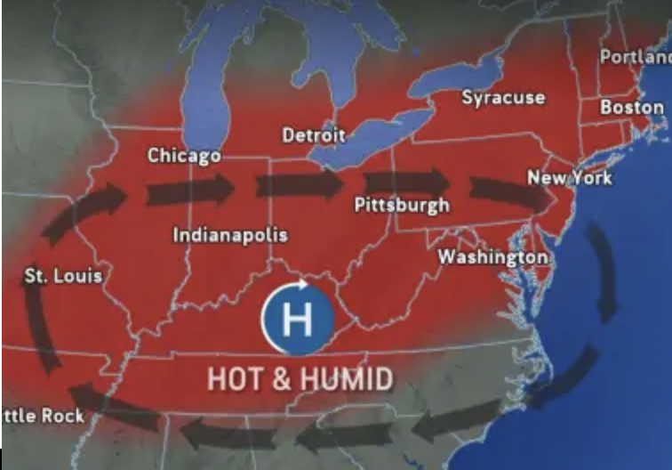
The heat is expected to rise again in New Hampshire, following the current decrease in humidity. After experiencing a welcomed stretch of lower humidity and cooler temperatures, a surge of intense heat is set to push in from a powerful heat dome hovering over the central United States this Thursday and Friday with record heat. Fortunately, a cold front is on track to sweep through, effectively reducing the heat in New England and parts of the mid-Atlantic by Sunday.
Weather Patterns We’re Watching
Next week the last four days of July temperatures in the 80s with moderate levels of humidity.
Get Out!
Take a Hike: Summits above 4,000 feet: Partly sunny skies with highs reaching the mid-60s, except approximately 60 degrees at elevations above 5, feet. West winds up to 10, with gusts reaching up to 25 mph. Elevations between 2,500 and 4,000 feet: Partly sunny. Highs in the lower 70s. Light and variable winds.
Hit the Beach Hampton & Rye Beach
Weather: Sunny.
UV Index: Very high.
Thunderstorm Potential: None.
High Temperature: In the mid 70s.
Winds: Southwest winds at approximately 5 mph shifting to southeast in the afternoon.
Surf Height: Around 1 foot.
Water Temperature: 63 degrees.
Rip Tide Current Risk: Low.
Tides Hampton Beach: High 8.2 feet (MLLW) 10:46 AM. Low 0.5 feet (MLLW) 04:55 PM.
Jump in a Lake Weirs Beach:
West winds at approximately 5 mph. Waves under 1 foot. Clear skies and sunny conditions. High temperatures in the lower 80s. Water temperature at 73 degrees.