
Rick Gordon’s Weather Watch
Follow our YouTube channel here.
Today’s Weather
Get ready for a warm day ahead! The sun will be shining hazily as temperatures rise to a high of 91, but with the humidity creeping up, it might feel more like 93. A gentle breeze from the south-southwest at 5-10 mph will offer just a hint of relief. Stay cool and hydrate!
Weather Alerts
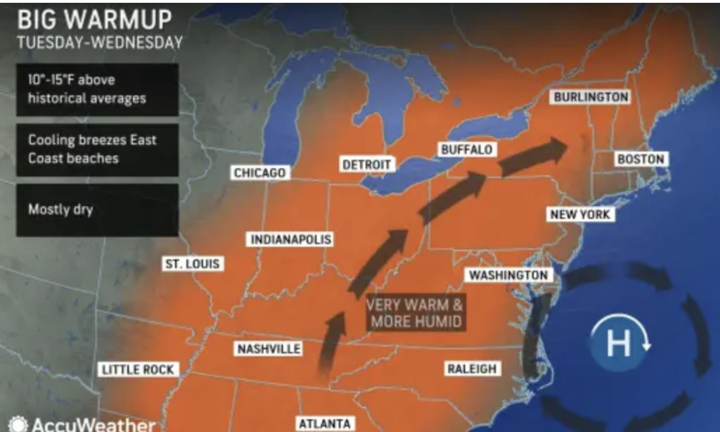
New Hampshire is set to experience the warmest weather since September. While Memorial Day weekend is often regarded as the unofficial start of summer, residents across the Granite State have been enduring a prolonged spring chill accompanied by frequent rain. However, this week marks the long-awaited shift to warmer conditions. Elevated humidity levels will create a midsummer-like feel, with “feels-like” temperatures soaring into the 90s when considering factors such as humidity and sunshine intensity. It is to exercise caution when engaging in outdoor activities or strenuous physical exertion during the peak heat of the day.
5-Day Outlook
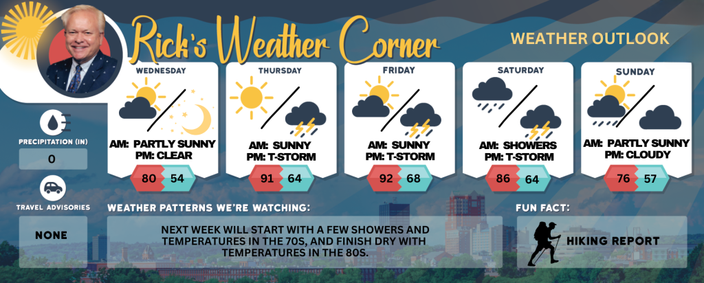
Today: Hazy sun & hot with increasing humidity. High 91 (feel like 93) Winds: SSW 5-10 mph
Tonight: Mainly clear, mild, and humid. Low 62 Winds: SSW 5-10 mph
Thursday: Hazy sun, hot, and muggy with a gusty thunderstorm late in the afternoon; caution advised if doing strenuous activities outside. High 94 (feel like 98) Winds: SSW 5-15+ mph
Thursday night: Partly cloudy, warm, and humid. Low 68 Wind: Light & Variable
Friday: Not as hot with some sun, warm, & humid with spotty afternoon thunderstorms. High 86 (feel like 92) Winds: W 5-15 mph
Friday night: Mild and humid with periods of showers and a thunderstorm. Low 64 Winds: SSE 5-10 mph
Saturday: Not as warm but humid with morning showers giving way to afternoon thunderstorms. High 74 Winds: SSW 5-10 mph
Saturday night: A couple of evening thunderstorms; otherwise, clearing and turning less humid. Low 60 Winds: NNE 5-15 mph
Sunday: Early morning showers followed by some sun & clouds. High 76 Winds: NW 5-10 mph
Sunday night: Partly cloudy. Low 57 Winds: Light & Variable
Weather Patterns We’re Watching
Next week will start with a few showers and temperatures in the 70s, and finish dry with temperatures in the 80s.
Get Out!
Take a Hike: Summits above 4,000 feet: Partly sunny. Haze. Highs in the lower 70s. Southwest winds 10 to 20 mph with gusts up to 35 mph. Elevations between 2,500 and 4,000 feet: Partly sunny. Haze. Highs in the upper 70s. Southwest winds 10 to 15 mph with gusts up to 30 mph.
Hit the Beach Hampton & Rye Beach Weather: Hazy sunshine. UV index: Very high. Thunderstorm Potential: None High Temperature: In the lower 70s. Winds: South winds 5 to 10 mph. Surf Height: Around 2 feet. Water Temperature: 54 degrees. According to the USCG, when the water temperature is below 60 degrees, the average submerged person could lose dexterity within minutes and be unable to accomplish simple tasks like buckling a life jacket or operating a radio. Rip Tide Current Risk: Low.
Jump in a Lake Weirs Beach Southwest winds at 5 to 10 mph. Waves approximately 1 foot. Hazy sunshine with temperatures reaching the mid-80s. Water temperature is 56 degrees.