
Rick Gordon’s Weather Watch
Follow our YouTube channel here.
Today’s Weather
Partly sunny, humid, and extremely hot with isolated thunderstorms in the afternoon; storms may bring heavy rainfall and localized damaging wind gusts. High of 97 (feels like 99). Winds: SW at 5-10 mph.
5-Day Outlook
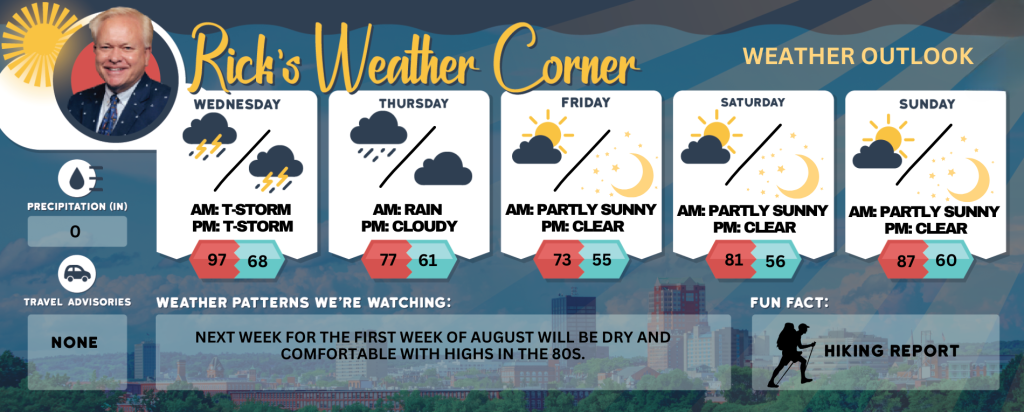
Today: Partly sunny, humid, and very hot with spot thunderstorms in the afternoon; storms can bring flooding downpours and localized damaging wind gusts. High 97 (feel like 99) Winds: SW 5-10 mph
Tonight: Evening thunderstorm & humid. Low 68 Winds: W 5-10 mph
Thursday: Not as warm, accompanied by clouds with a couple of showers that gradually give way to lower humidity. High 77 Winds: NNE 5-10 mph
Thursday night: Some rain (.50″). Low 61 Winds: NNE 5-10 mph
Friday (August 1st): Cloudy, cool, & less humid with some showers. High 73 Winds: NE 5-10 mph
Friday night: Clearing & cool. Low 55 Winds: N 5-10 mph
Saturday: Mostly sunny & nice. High 81 Winds: NW 5-10 mph Saturday night: Clear & cool. Low 56 Winds: Light & Variable
Sunday: Comfortable sunshine and warmer. High 87 Winds: WSW 5-10 mph
Sunday night: Clear to partly cloudy. Low 60 Winds: SW 5-10 mph
How Hot Was It?
Yesterday’s record high temperature of 100 surpassed the previous record of 97 degrees set in 1949. Today will be the last day of our fourth heat wave of the summer, followed by a cool down with comfortable air arriving on Thursday and continuing into the first weekend of August. Today heat index values into the upper 90s. Drink plenty of fluids, stay in an air-conditioned room, stay out of the sun and check up on relatives, neighbors, children, and pets.
Weather Patterns We’re Watching
Next week for the full week of August will be dry and comfortable with highs in the 80s.
Get Out!
Take a Hike: Summits above 4,000 feet: Mostly cloudy. Showers likely with a chance of thunderstorms in the afternoon. Highs around 70…except in the mid 60s at elevations above 5000 feet. West winds 15 to 25 mph with gusts up to 40 mph. Chance of rain 60 percent. Elevations between 2,500 and 4,000 feet: Summits in and out of clouds in the morning, then becoming cloudy. A chance of showers in the morning, then showers likely with a chance of thunderstorms in the afternoon. Highs in the lower 70s. West winds 10 to 15 mph with gusts up to 40 mph. Chance of rain 70 percent.
Hit the Beach Hampton & Rye Beach
Weather: Humid with sunshine transitioning to increasing cloud cover, accompanied by a thunderstorm in the afternoon.
UV Index: Moderate.
Thunderstorm Potential: Slight.
High Temperature: 84.
Winds: Southeast 5-10 mph
Surf Height: Around 1 foot.
Water Temperature: 62 degrees.
Rip Tide Current Risk: Low.
Tides Hampton Beach: Low 0.6 feet (MLLW) 10:17 AM. High 8.3 feet (MLLW) 04:17 PM.
Jump in a Lake
Southwest winds at approximately 5 mph. Waves around 1 foot. Patchy fog expected in the morning, followed by sunny conditions. Partly sunny with likely showers and a chance of thunderstorms in the afternoon. Humid, with high temperatures reaching the upper 80s. Probability of rain is 60 percent. Water temperature is 74 degrees.