Rick Gordon’s Weather Watch
Follow our YouTube channel here.
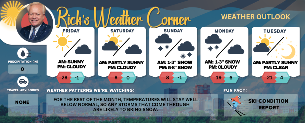
Weather Watch
The weekend kicks off with frigid temperatures and wraps up with a winter storm watch as a major snowstorm rolls in. Brace yourselves! The winter chill is about to deepen as we brace for the season’s most intense snowstorm. Get ready for a dramatic drop in temperatures and a heavy blanket of snow like we haven’t seen yet this winter!
Saturday: Prepare for a windy and bitterly cold day filled with abundant sunshine. The high temperature will only reach a frigid 8°, but with the wind chill, it will feel like a chilling -5°. Notably, this temperature breaks the record low high of 9°F set back in 2011. Expect brisk winds from the northwest at 10-15 mph, adding to the chill in the air.
Saturday Night: The evening will turn partly to mostly cloudy with frigid conditions taking hold. Temperatures will drop to a low of 0°, feeling like a harsh -10°cdue to the wind. Winds will shift to the northwest at a gentle 5-10 mph, keeping the cold firmly entrenched.
Sunday: We’re monitoring a potential winter storm that could bring significant snowfall. The day will be overcast and chilly, with snow beginning to fall, accumulating between 1-3 inches. The high will only reach a frigid 12°, while the wind chill will make it feel like a mere 2°. Northeasterly winds will blow at 5-10 mph, stirring the cold air.
Sunday Night: Expect heavy snowfall at times, with totals ranging from 5-8 inches overnight. Temperatures will hover around 10, but with the wind, it will feel like a biting -1°. Winds from the northeast will increase to 5-15 mph, contributing to a wintry landscape.
Monday: The frigid cold persists, accompanied by additional snowfall of 1-3 inches, along with blowing and drifting snow. Total snowfall accumulations could reach between 7-14 inches; however, variations in the storm’s path may lead to differences in these amounts. The high temperature will climb to a mere 19°, while the wind chill will make it feel like 10°, with winds blowing from the north at 10-15 mph, keeping the winter weather firmly in place.
Saturday: Morning Cold Weather Advisory: Expect breezy, brutally cold conditions with plenty of sunshine. High near 8 degrees (feels like -5), approaching the record low high of 9 set in 2011. Winds from the NW at 10-15+ mph.
Saturday night: Partly to mostly cloudy and frigid. Low 0 (feel like -10) Winds: NW 5-10 mph
Sunday: Watching a potential winter storm. Cloudy and frigid with snow (1-3″) developing. High 12 (feel like 2) Winds: NNE5-10 mph
Sunday night: Snow heavy at times (5-8″). Low 10 (feel like -1) Winds: NNE 5-15+ mph
Monday: Cold with some snow (1-3″) with blowing & drifting snow; storm total 7-14″; the exact track of the storm could bring variations in snow totals. High 19 (feel like 10) Winds: N 10-15+ mph
Monday night: Snow showers (less than 1″) early with some clearing late. Low 6 (feel like -6) Winds: NW 5-15+ mph
Tuesday: Very cold with some sun & clouds. High 21 (feel like 8) Winds: WNW 10-15 mph Tuesday night: Mainly clear & frigid. Low 4 (feel like -2) Winds: W 5-10 mph
Weather Patterns We’re Watching
For the rest of the month, temperatures will stay well below normal, so any storms that come through are likely to bring snow.
Get Out!
Elevations for summits above 4,000 feet in Northern New Hampshire today: Summits will be hidden with a chance of snow showers. Highs will range from 3 to 13 degrees above zero. West winds will blow at 25 to 35 mph, with speeds increasing to around 45 mph above 5,000 feet, and up to 55 mph in the afternoon. There’s a 50 percent chance of snow, and wind chill values could drop as low as 49 below.
Elevations between 2,500 and 4,000 feet in Northern New Hampshire today: The summits will be hidden, with a chance of snow showers in the afternoon. Temperatures will reach around 12 degrees, with west winds at 15 to 25 mph and gusts up to 60 mph. There’s a 50 percent chance of snow, and wind chills could drop as low as 23 below.