
Rick Gordon’s Weather Watch
Follow our YouTube channel here.
Today’s Weather
There’s a slight chance of morning showers, but otherwise, the day will be partly sunny and humid. The rain won’t do much to ease the recent drought conditions. Expect a high of 83 (feels like 85) with winds coming from the SSW at 10-15 mph.
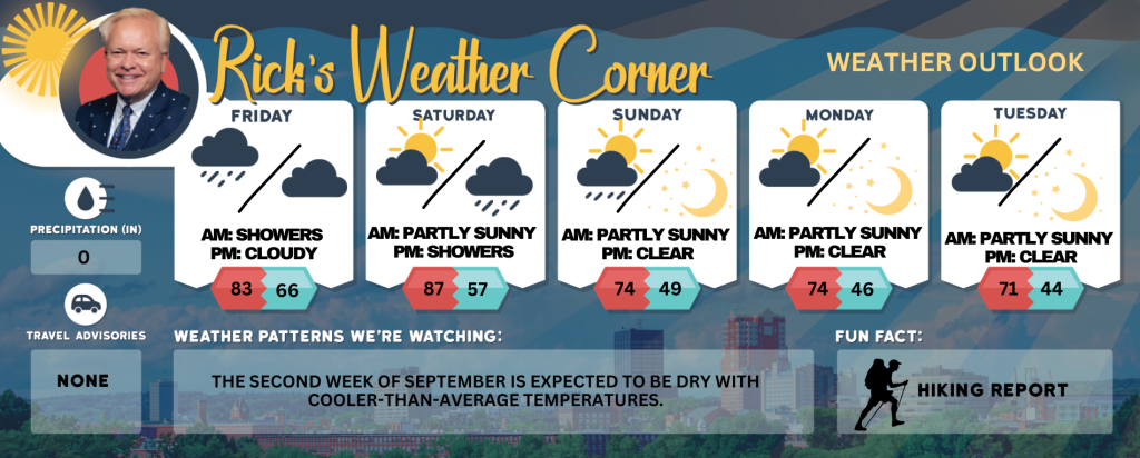
Today: A slight chance of showers early morning; otherwise, partly sunny & humid; the rain will do little to alleviate the recent drought conditions. High 83 (feel like 85) Winds: SSW 10-15 mph
Tonight: Clear to partly cloudy & humid. Low 66 (feel like 68) Winds: S 5-10 mph
Saturday: Humid & very warm with some sun, a couple of showers and a thunderstorm (.25″), mainly later. High 87 (feel like 91) Winds: SSW 10-15 mph
Saturday night: Spot thunderstorms (.20″) early and turning less humid late. Low 57 Winds: W 5-10 mph
Sunday: Early showers (.15″), then intervals of clouds and sunshine in the afternoon. High 74 Winds: Light & Variable
Sunday night: Clear & chilly. Low 49 Winds: Light & Variable
Monday: Some sun & pleasant. High 74 Winds: NW 5-10 mph
Monday night: Clear & chilly. Low 46 Winds: Light & Variable
Tuesday: Sunny, cool, with a fall feel. High 71 Winds: Light & Variable
Tuesday night: Clear & chilly. Low 44 Winds: Light & Variable
Forecast for the first weekend in September
Day-by-Day Breakdown
Saturday: Expect a very warm, humid day with partial sunshine. Scattered showers and a thunderstorm (up to 0.25″) are most likely later in the afternoon and evening.
Saturday Night Early spotty thunderstorms (around 0.20″) give way to drier, less humid conditions by late night. Temperatures drop into the upper 50s.
Sunday Morning showers (about 0.15″) clear out by mid-morning. The afternoon mixes clouds and sun, with highs near 74°F.
Sunday Night A crisp, clear night with lows around 49°F—perfect for watching the stars.
Weekend Tips
Bring rain gear for any outdoor plans Saturday afternoon and Sunday morning. Stay hydrated—high humidity will make it feel hotter on Saturday. Layer up Sunday night; temperatures dip significantly.
Weather Patterns We’re Watching
The second week of September is expected to be dry with cooler-than-average temperatures.
Get Out!
Take a Hike: Summits above 4,000 feet: Summits will be obscured in the morning, with periods of clearing as clouds move in and out. There’s a chance of showers, with highs in the lower 60s, dropping to the mid-50s at elevations above 5,000 feet. South winds will range from 15 to 25 mph, with gusts up to 50 mph. The chance of rain is 50 percent.
Elevations between 2,500 and 4,000 feet: Summits will be hidden in the morning, with occasional appearances through the clouds later. There’s a chance of showers, with highs reaching the mid-60s. South winds will blow at 10 to 15 mph, with gusts up to 35 mph. The chance of rain is 50 percent.
Hit the Beach Hampton & Rye Beach Weather: The weather starts mostly cloudy until 9 AM, transitioning to mostly sunny with patchy fog and a chance of showers. There’s no thunderstorm potential, and temperatures will reach the mid-70s. South winds will blow around 10 mph. Surf height will be about 3 feet, and the rip current risk is low. Ocean water temperature is 63 degrees. For tides at Hampton Beach, high tide is 7.7 feet (MLLW) at 10:15 AM, and low tide is 1.0 feet (MLLW) at 4:23 PM.
Jump in a Lake Weirs Beach: South winds at 5 to 10 mph. Waves at the north end of the lake will start at less than 1 foot, increasing to around 2 feet by the afternoon. At the south end, waves will stay around 2 feet. Expect patchy fog in the morning, with mostly cloudy skies and a slight chance of showers early, turning partly sunny with a chance of showers in the afternoon. Highs will reach the upper 70s, with a 30 percent chance of rain. Water temperature is 70 degrees.