
Rick Gordon’s Weather Watch
Follow our YouTube channel here.
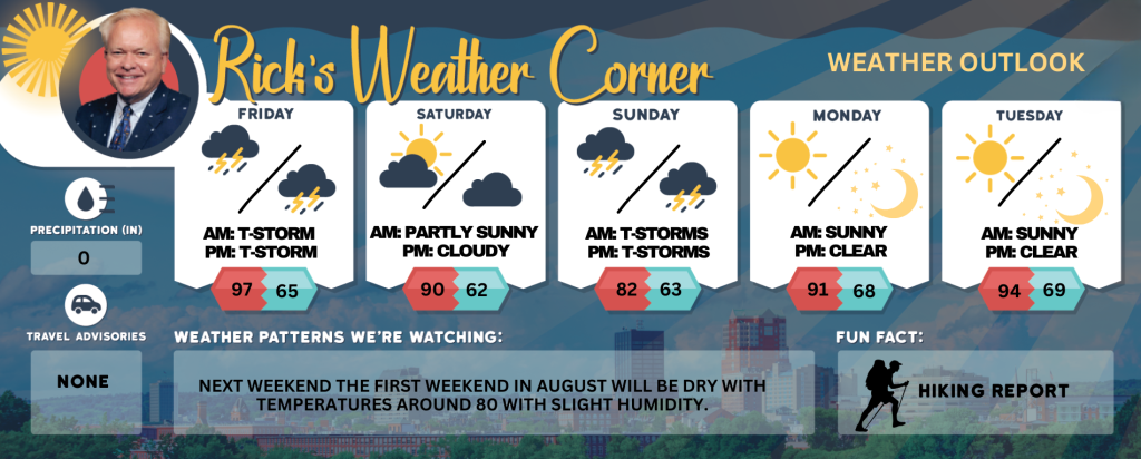
Today’s Weather
Hazy and extremely hot with record-breaking temperatures. Breezy and humid conditions will lead to strong afternoon thunderstorms. High of 97 degrees, breaking the previous record of 93 set in 2016, with a feels-like temperature of 101 degrees. Winds from the west-southwest at 15 to 20 mph. HEAT ADVISORY IN EFFECT FROM 10 a.m. TO 8 p.m. Heat index values up to 101 expected.
5-Day Outlook
Today: Hazy, very hot with record heat, breezy, and humid with strong afternoon thunderstorms. High 97 (record 93 set in 2016) (feel like 101) Winds: WSW 15-20 mph
Tonight: Humid with scattered thunderstorms expected early, followed by clearing later. Low 65 (feel like 67) Winds: NW 5-10 mph
Saturday: Some sun & clouds, hot, and less humid. High 90 Winds: NE 5-10 mph
Saturday night: Partly cloudy. Low 62 Winds: SSE 5-10 mph
Sunday: More humid with times of clouds and sun; an afternoon thunderstorm in the area. High 82 (feel like 87) Winds: S 5-10
Sunday night: Evening thunderstorm & humid. Low 63 (feel like 65) Winds: ESE 5-10 mph
Monday: Mostly sunny, hot, and humid. High 91 (feel like 97) Winds: W 5-15 mph
Monday night: Mainly clear and humid. Low 68 (feel like 71) Winds: S 5-10 mph
Tuesday: Some sun & clouds, hot, and humid. High 94 (feel like 97) Winds: W 5-15 mph
Tuesday night: Mainly clear & humid. Low 69 (feel like 71) Winds: W 5-15 mph
Last Weekend of July Overview
🌤️ Saturday – Summer’s Prime Conditions: A blend of sunshine and clouds, warm but not overly intense. High: 90°F Winds: Southwest at 5–10 mph Atmosphere: Perfect for beach activities, hiking, or late-July barbecues. Evening: Partly cloudy, low of 62. ️
Sunday – Sweltering Transition Conditions: Increased humidity, partly sunny with scattered thunderstorms in the afternoon—afternoon plans may require adjustments. High: 82°F (heat index of 87°F) Winds: South at 5–10 mph Evening: Thunderstorms, humid and clearing—a sticky conclusion to the weekend.
Weather Patterns We’re Watching
Next weekend the first weekend in August will be dry with temperatures around 80 with slight humidity.
Get Out!
Take a Hike: Summits above 4,000 feet: Summits will remain obscured. Showers are likely, accompanied by scattered thunderstorms. Temperatures will reach highs in the upper 60s, except for the lower 60s at elevations above 5000 feet. West winds will range from 20 to 30 mph, with gusts up to 65 mph. The chance of rain is 70 percent. Elevations between 2,500 and 4,000 feet: Summits will be obscured in the morning, transitioning to periods summits appearing and disappearing through the clouds. Show are probable, accompanied by scattered thunderstorms. Temperatures will reach highs in the lower 70s. West winds will range from 10 to 20 mph, with gusts reaching up to 45 mph. The chance of rain is 70 percent.
Hit the Beach Hampton & Rye Beach
Weather: Mostly sunny until 5 PM, then mostly cloudy. Showers likely and scattered thunderstorms.
UV Index: Very high.
Thunderstorm Potential: Moderate.
High Temperature: In the upper 80s.
Winds: Southwest winds around 10 mph.
Surf Height: Around 2 feet.
Water Temperature: 61 degrees.
Rip Tide Current Risk: Low.
Tides Hampton Beach: Low -0.7 feet (MLLW) 06:38. High 8.5 feet (MLLW) 12:34 PM.
SATURDAY…Surf height around 1 foot. Mostly sunny. Not as warm. Highs in the upper 70s. Northeast winds around 5 mph.
SUNDAY…Surf height around 2 feet. Partly sunny. A chance of showers and scattered thunderstorms. Highs in the upper 70s. South winds around 10 mph.
Jump in a Lake Weirs Beach:
Winds from the west at approximately 10 mph. Waves around feet. Partly sunny skies. A of showers with isolated thunderstorms in the morning, transitioning to likely showers with scattered thunderstorms in the afternoon. Humid conditions with temperatures reaching the upper 80s. Probability of precipitation is 70 percent. Water temperature is 72 degrees.