Rick Gordon’s Weather Watch
Follow our YouTube channel here.
Today’s Weather
Winter has made its return with a brisk chill in the air! Expect temperatures to reach a high of 29°, but with the wind chill, it will feel more like 18°. Winds will be quite strong, blowing from the west at 15 to 20 mph, with occasional gusts reaching 33 mph. The sky will be a mix of sun and clouds, creating a dynamic winter atmosphere. Bundle up if you’re heading outside, as the combination of cold temperatures and blustery winds will make it feel much colder!
🌨️ MLK Jr. Weekend Weather Overview
📅 Storm Timeline
SATURDAY — First Weak System Morning–Early Afternoon Mostly cloudy, quiet. No snow yet. Mid–Late Afternoon (2–5 PM) Light snow or flurries develop. Intensity: very light. Accumulation: Up to 1″. Evening–Early Night (6–10 PM) Periods of light snow continue. Roads may become slick as temps fall below freezing. Late Night (10 PM–2 AM) Snow tapers off. Total Saturday accumulation: 1–2″ max. Impacts: Minor travel issues after sunset. No wind concerns.
SUNDAY — Calm Start, Second Wave Approaches Morning–Afternoon Cloudy, quiet. No significant snow during the day. Evening (5–9 PM) Snow showers develop as the next disturbance approaches. Light, scattered, not yet the main storm.
SUNDAY NIGHT — Coastal Storm Wildcard This is the period with the highest uncertainty and highest impact potential. Timing Possible start: 8 PM–Midnight Peak window (if storm tracks close enough): Midnight–6 AM End: Early Monday morning. Two Main Scenarios
1️⃣ Storm Tracks Farther Offshore (Lower Impact) Light snow or flurries only. Accumulation: Coating to 2″. Minimal wind.
2️⃣ Storm Tracks Closer to the Gulf of Maine (Higher Impact) Steadier snow overnight. Accumulation: 3–6″+ possible. Winds increase from the west after the storm passes. Impacts (Both Scenarios) Slippery roads overnight into early Monday. Reduced visibility during any steadier snow. Coastal flooding risk is low because tides are not extreme.
MLK JR. DAY (MONDAY) — Storm pulls away morning, any leftover snow ends early. Clouds break for some sun. Afternoon Breezy and cold. High 33° but feels like mid‑20s. Impacts Blowing snow possible in open areas. Cold wind chills for outdoor events.
MONDAY NIGHT — Arctic Air Arrives Low near 9°F, wind chills near –4°F. Risk of icy roads from refreeze. Exposed pipes and pets need protection.
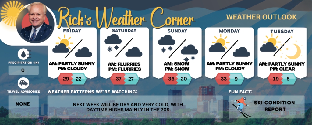
Friday: Colder & windy with a mix of sun and clouds. High 29 (feel like 18) Winds: W 15-20+ mph
Friday night: Cloudy. Low 22 Winds: Light & Variable
Saturday: Cloudy with some afternoon light snow or flurries up to an inch possible. High 37 (feel like 33) Winds: SSW 5-10 mph
Saturday night: Periods of light snow early with an inch possible. Low 27 Winds: Light & Variable
Sunday: Cloudy with some snow showers by evening. High 36 (feel like 29) Winds: W 5-10 mph
Sunday night: Mostly cloudy, with the possibility of accumulating snow depending on the path of a coastal storm. Low 20 Winds: W 5-10 mph
M.L.K. Jr. Day: Breezy with some sun & clouds. High 33 (feel like 24) Winds: WSW 10-15+ mph
Monday night: Partly cloudy, breezy, and frigid. Low 9 (feel like -4) Winds: W 10-15 mph
Tuesday: Windy, very cold with sunshine and a few clouds. High 19 (feel like 0) Winds: W 10-20+ mph
Tuesday night: Mainly clear & frigid. Low 5 (feel like -3) Winds: W 5-10 mph
Weather Patterns We’re Watching
Next week will be dry and very cold, with daytime highs mainly in the 20s.
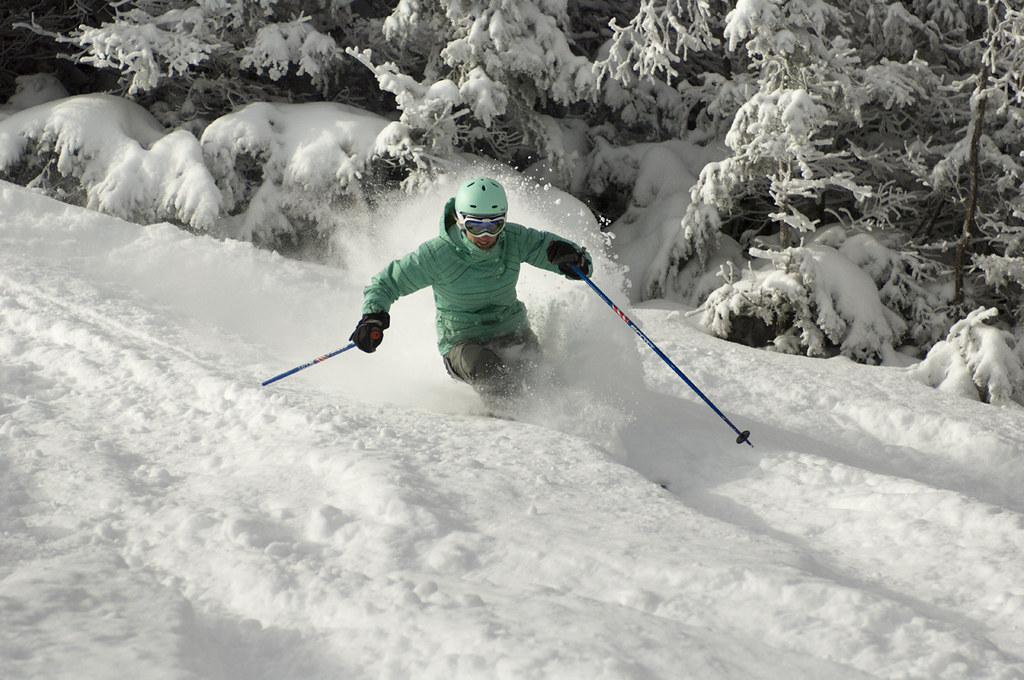
Get Out!
Elevations for summits above 4,000 feet in Northern New Hampshire today: Summits will be hidden, with highs near 9 degrees above zero. Northwest winds will blow at 30 to 40 mph, with gusts reaching up to 85 mph. Wind chill could make it feel as cold as 41 below.
Elevations between 2,500 and 4,000 feet in Northern New Hampshire today: Summits are hidden, with highs ranging from 6 to 16 degrees above. Northwest winds will blow at 15 to 25 mph, with gusts reaching up to 55 mph. Wind chill could make it feel as cold as 26 below.