
Rick Gordon’s Weather Watch
Follow our YouTube channel here.
Today’s Weather
Get ready for a lovely day with partial sunshine! Temperatures will rise to 85 degrees, but it may feel like 88 due to the humidity. A gentle southeast breeze of 5 to 10 mph will provide just the right amount of comfort. It’s a great opportunity to enjoy the outdoors, so don’t miss out!
🌤️ Manchester and Nashua Weekend Weather Outlook
Hot & Humid—Plan Smart for Outdoor Fun
☀️ Saturday 📈 High: 85° (feels like 92°) 🌙 Low: 67° (fog late, feels like 69°) 🌬️ Winds: SE 5–10 mph 🏖️ Best Bet: Early beach time before fog rolls in. 🥾 Hiking Note: Humidity will sap energy, even at lower elevations.
☀️ Sunday 📈 High: 88° (feels like 92°) 🌙 Low: 66° (feels like 68°) 🌬️ Winds: SSE 5–10 mph 💧 Hydration Alert: Dangerous heat index midday. ☀️ UV Index: Moderate to High — sunscreen is a must. 🌅 Sunset Views: Hazy glow possible through patchy clouds.
🧭 Outdoor Snapshot Beach Time👍 Morning Fog risk Saturday; sunshine stronger Sunday. Hiking😓 Challenging. Muggy conditions, slippery trails. Cookouts🍔 Manageable Have shade & cold drinks ready. Night Events 🌫️ Foggy feel. Humid evenings, limited breeze.
5-Day Outlook
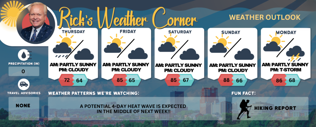
Friday: Some sun, warmer, and humid. High 85 (feel like 88) Winds: SSE 5-10 mph
Friday night: Partly cloudy and humid. Low 67 (feel like 68) Winds: Light & Variable
Saturday: Some sun, muggy, and warm. High 85 (fell like 92) Winds: SE 5-10 mph
Saturday night: Partly cloudy and humid with fog late. Low 67 (feel like 69) Winds: SE 5-10 mph
Sunday: Some sun, very warm, and muggy. High 88 (feel like 92) Winds: SSE 5-10 mph
Sunday night: Partly cloudy and humid. Low 66 (feel like 68) Winds: SSE 5-10 mph
Monday: Muggy with some sun & clouds with a spot afternoon thunderstorm. High 86 (feel like 90) Winds: SSW 5-10 mph
Monday night: Humid with a spot evening thunderstorm. Low 68 (feel like 69) Winds: SSW 5-10 mph
Tuesday: Mostly sunny, hot (the start of or 3rd heat wave), and muggy. High 90 (feel like 96) Winds: Light & Variable
Tuesday night: Clear and humid. Low 69 (feel like 71) Winds: Light & Variable
Weather Patterns We’re Watching
A potential four-day heat wave is anticipated to begin next Tuesday and extend through Friday.
Get Out!
Take a Hike: Summits above 4,000 feet: Summits in and out of clouds. Highs in the upper 60s… except in the lower 60s at elevations above 5000 feet. Southwest winds up to 10 mph with gusts up to 20 mph. Elevations between 2,500 and 4,000 feet: Mostly cloudy. Scattered showers in the morning. Highs in the lower 70s. Light and variable winds. Chance of rain 50 percent.
Hit the Beach Hampton & Rye Beach
Weather: Mostly cloudy conditions will persist until 2 PM, followed by mostly sunny skies. Patchy fog is expected.
UV Index: Moderate.
Thunderstorm Potential: None.
High Temperature: In the lower 70s.
Winds: East winds around 5 mph.
Surf Height: Around 1 foot.
Water Temperature: 62 degrees.
Rip Tide Current Risk: Low.
Tides Hampton Beach: Low 0.1 feet (MLLW) 06:50 AM. High 7.7 feet (MLLW) 12:47 PM.
Jump in a Lake Weirs Beach:Light and variable winds becoming southwest around 5 mph in the afternoon. Waves less than 1 foot. Partly sunny. Warmer with highs around 80. Water temperature 70 degrees.