
GRAY, Maine – A winter storm watch is in effect for the region with heavy snowfall expected in New Hampshire starting Sunday night. As of now the weather watch is in effect from Feb. 22 at 7 p.m. until Feb. 24 at 1 a.m.
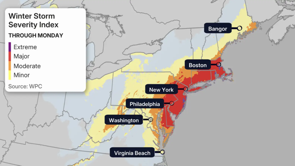
The path of Weather Storm Hernando has shifted over the past 24 hours and is expected to bring as much as 20 inches of snow to parts of the Northeast Sunday into Monday, the National Weather Service said Saturday, Feb. 21.
The National Weather Service in Gray, Maine, issued the following storm watch for New Hampshire:
* WHAT…Heavy snow and blowing snow possible. Total snow accumulations greater than 6 inches possible. Winds could gust as high as 45 mph.
* WHERE…Portions of southwest Maine and central and southern New Hampshire.
* WHEN…From Sunday evening through late Monday night.
* IMPACTS...Visibilities may drop below 1/4 mile due to falling and blowing snow. Periods of moderate and heavy snow will combine withlow visibility to create dangerous driving conditions. The hazardous conditions could impact the Monday morning and evening commutes. Gusty winds will blow around unsecured objects and break some tree limbs. The power outage threat is limited.
PRECAUTIONARY/PREPAREDNESS ACTIONS… Monitor the latest forecasts for updates on this situation. Persons should consider delaying all travel. Motorists should use
extreme caution if travel is absolutely necessary.
The Week Ahead
Sunday– A 20 percent chance of snow after 3 p.m. Mostly cloudy, with a high near 33. Calm wind becoming east around 5 mph in the afternoon.
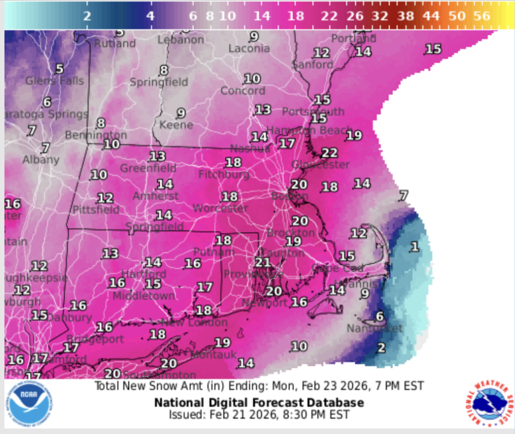
Sunday Night – Snow, mainly after midnight. Low around 23. Northeast wind 5 to 15 mph, with gusts as high as 25 mph. Chance of precipitation is 90%. New snow accumulation of 1 to 3 inches possible.
Monday – Snow. Patchy blowing snow. High near 28. Blustery, with a north wind around 20 mph, with gusts as high as 35 mph. Chance of precipitation is 90%. New snow accumulation of 4 to 8 inches possible.
Monday Night – Snow likely, mainly before 8pm. Mostly cloudy, with a low around 18. Northwest wind around 15 mph, with gusts as high as 25 mph. Chance of precipitation is 60%. New snow accumulation of less than a half inch possible.
Tuesday – Mostly sunny, with a high near 30.
Tuesday Night – Partly cloudy, with a low around 7.
Wednesday – Snow likely, mainly after 11am. Mostly cloudy, with a high near 32. Chance of precipitation is 60%.
Wednesday Night – A 50 percent chance of snow. Mostly cloudy, with a low around 21.
Thursday – A 40 percent chance of rain. Partly sunny, with a high near 42.
Thursday Night – Rain and snow likely. Mostly cloudy, with a low around 23. Chance of precipitation is 60%.
Friday – A chance of rain and snow. Partly sunny, with a high near 38. Chance of precipitation is 30%.
Friday Night – Mostly clear, with a low around 16.
Saturday – Mostly sunny, with a high near 44.