
Weather Watch with Rick Gordon
Click below for Rick’s exclusive videocast
Wednesday’s Weather
Expect a hot day with a mix of clouds and sunshine. Be on the lookout for a severe thunderstorm in the afternoon; such storms may cause flash flooding, hail, and damaging wind gusts. The high will be 95 degrees, feeling like 102.
Weather Alert
Today is the 12th straight day of 90-degree weather, making the second heat wave lasting over a week, with temperatures expected to remain at or above 90 degrees through today. Yesterday’s high broke the record of 96 set in 1968. It sounds like you have quite the weather ahead! Severe thunderstorms can indeed be intense. Here are some safety tips to keep in mind:
1. **Stay Informed**: Keep an eye on weather updates through Manchester & Nashua Ink Link. A severe thunderstorm watch means conditions are favorable, while a warning means a storm is imminent or occurring.
2. **Seek Shelter**: If a severe thunderstorm warning is issued, move to a sturdy building. Avoid small sheds, isolated trees, and convertible automobiles. If you’re outside, get inside a hard-top vehicle and keep the windows up.
3. **Secure Outdoor Items**: Bring in or secure any outdoor furniture, grills, or other items that could become projectiles in high winds.
4. **Avoid Electrical Appliances**: During the storm, avoid using electrical equipment and corded phones. Use battery-powered or hand-crank radios to stay updated.
5. **Stay Away from Windows**: High winds and hail can shatter windows, so it’s best to stay in an interior room away from them. Stay safe and take care!
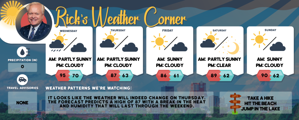
5-Day Forecast July 15-July 19
Today: Hot with clouds and sun; watch for a severe afternoon thunderstorm; thunderstorms can bring flooding downpours, hail, and damaging wind gusts. High 95 (feel like 102) Winds: SW 10-15 mph
Tonight: Cloudy and humid; a couple of evening showers followed by occasional rain and a thunderstorm late. Low 70 Winds: SW 5-10 mph
Thursday: Not as hot and turning less humid with some sun. High 87 Winds: WNW 10-15 mph
Thursday night: Mainly clear. Low 63 Winds: NW 5–10 mph
Friday: Mostly sunny & comfortable. High 86 Winds: WNW 5-10 mph
Friday night: Few clouds. Low 61 Winds: W 5-10 mph
Saturday: Very warm with a mix of sun and clouds. High 89 Winds: W 5-10 mph
Saturday night: Mainly clear & comfortable. Low 62 Winds: W 5-10 mph
Sunday: Some sun & comfortable but hot. High 90 Winds: WNW 5-10 mph
Sunday night: Some clouds & comfortable. Low 62 Winds: NNW 5-10 mph
Weather Patterns We’re Watching
It looks like the weather will indeed change on Thursday. The forecast predicts a high of 87 with a break in the heat and humidity that will last through the weekend.
Hiking/Beach/Lake Forecasts
Take a Hike
Elevations for summits above 4,000 feet in Northern New Hampshire Today: Mostly cloudy in the morning, then summits in and out of clouds. A chance of showers and thunderstorms in the afternoon. Highs in the lower 70s… except in the mid-60s at elevations above 5,000 feet. West winds 10 to 20 mph with gusts up to 40 mph. Chance of rain 50 percent.
Elevations between 2,500 and 4,000 feet in Northern New Hampshire Today: It sounds like a mixed day ahead! Starting cloudy with some peaks of sunshine, and then a chance of showers and thunderstorms in the afternoon. Temperatures will be in the mid-70s, with west winds blowing at 10 to 15 mph and gusts up to 30 mph. There’s a 50% chance of rain, so you might want to keep an umbrella handy just in case!
Hit the Beach
- Weather: The weather will be mostly sunny until 11 AM, followed by partly sunny conditions. Expect patchy fog with the possibility of showers and thunderstorms.
- UV Index: High.
- Thunderstorm Potential: Moderate. Implies that thunderstorms are possible. High Temperature: In the mid-80s.
- Winds: Southwest winds around 10 mph.
- Water Temperature: 60 degrees.
- Surf Height: Around 2 feet.
- Rip Tide Current Risk: Low.
- Tides Hampton Beach: High 7.0 feet (MLLW) 08:45 AM. Low 1.8 feet (MLLW) 02:48 PM.
Jump in a Lake
Southwest winds around 10 mph with gusts up to 20 mph. Waves around 2 feet. Partly sunny. A chance of showers and thunderstorms in the afternoon. Humid with highs in the upper 80s. Chance of rain 50 percent. The lightning threat is moderate, which implies that thunderstorms are possible. The water temperature is 78 degrees.