Rick Gordon’s Weather Watch
Follow our YouTube channel here.
Today’s Weather
Enjoy a day of sunshine sprinkled with a few clouds as temperatures dip to a chilly 35 degrees. Expect a gentle breeze from the west-northwest at 5 to 15 mph, perfect for snow clean up!
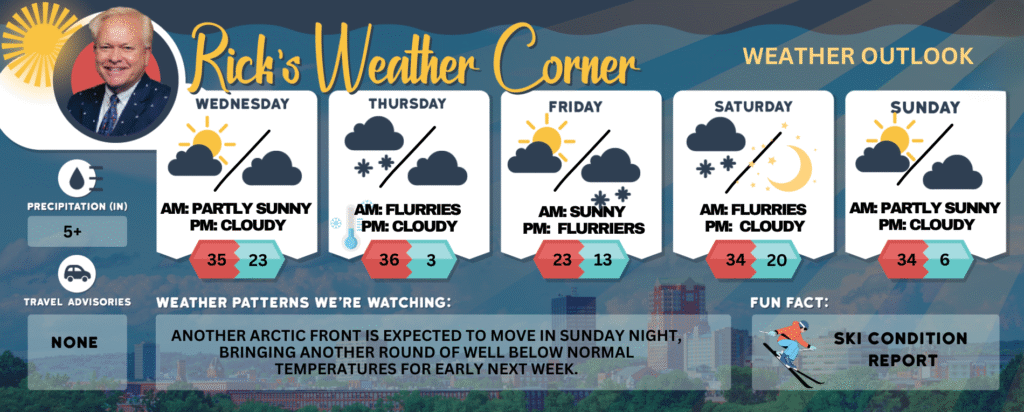
Today: Sunshine with some clouds & cold. High 35 (feel like 28) Winds: WNW 5-15 mph
Tonight: Partly cloudy & cold. Low 23 Winds: Light & Variable
Thursday: Cloudy & windy with an afternoon snow squall. High 36 (feel like 26) Winds: W 10-20 mph
Thursday night: Partly cloudy, breezy, and frigid with a record tying low of 3 set in 1886. Low 3 (feel like -2) Winds: NW 10-15+ mph
Friday: Mostly sunny & very cold. High 23 Winds: Light & Variable
Friday night: Partly to mostly cloudy with some lite snow late & cold. Low 13 Winds: Light & Variable
Saturday: Mostly cloudy and not as cold with some light snow. High 34 Winds: Light & Variable
Saturday night: Clearing & cold. Low 20 Winds: Light & Variable
Sunday: Some sun & clouds. High 34 (feel like 29) Winds: NW 5-15 mph
Sunday night: Some clouds & frigid. Low 6 (feel like 2) Winds: NW 5-15 mph
Preliminary Snow Totals as of Tuesday 5 p.m.
Hillsborough County (information from the National Weather Service
Hollis                                    3.4 in
Hudson                                 2.3 in
Manchester Airport           2.9 in
Nashua                                 3.5 in
Litchfield                            1.5 in
Weather Patterns We’re Watching
Another Arctic front is expected to move in Sunday night, bringing another round of well below normal temperatures for early next week.
Get Out!
Elevations for summits above 4,000 feet in Northern New Hampshire today: Summits drifting in and out of the clouds with highs near 19. Northwest winds around 30 mph shifting to the west at about 20 mph in the afternoon, with gusts reaching up to 60 mph. Wind chills could drop as low as 15 below.
Elevations between 2,500 and 4,000 feet in Northern New Hampshire today: In the morning, summits will be hidden, later shifting in and out of clouds. Temperatures will peak in the lower 20s, with northwest winds at 10 to 15 mph and gusts reaching up to 45 mph.