Rick Gordon’s Weather Watch
Follow our YouTube channel here.
Weather Watch
Expect 1-2 inches of snow to taper off and conclude by morning, but cloudy skies will persist through the afternoon. The high temperature will reach 37 degrees. Winds will be from the south at 5-10 mph.
Warming Trend
After today’s light snow, prepare for a fantastic warming trend that promises to elevate your spirits as we approach the weekend!
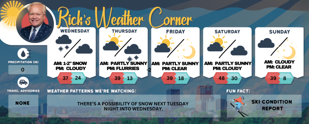
Today: Snow (1-2″) will taper off and end during the morning, but skies will remain cloudy during the afternoon. High 37 Winds: S 5-10 mph
Tonight: Some partial clearing late. Low 24 Winds: WSW 5-10 mph
Thursday: Not as cold with a mix of clouds and sunshine. High 39 (feel like 30) Winds: W 10-15 mph
Thursday night: Cloudy with a few flurries. Low 13 Winds: Light & Variable
Friday: Some sun & clouds. High 39 (feel like 37) Winds: W 5-10 mph
Friday night: Partly cloudy and cold. Low 18 Winds: Light & Variable
Saturday (Last day of February): Some sun & mild. High 48 (feel like 41) Winds: SSW 10-15 mph
Saturday night: Partly cloudy. Low 30 Winds: WNW 5-10 mph
Sunday: Partly to mostly cloudy and colder. High 39 (feel like 32) Winds: NW 10-15 mph
Sunday night: Mainly clear & very cold. Low 8 (feel like -1) Winds: NW 5-15 mph
Weather Patterns We’re Watching
There’s a possibility of snow next Tuesday night into Wednesday.
Get Out!
Elevations for summits above 4,000 feet in Northern New Hampshire today: The mountain tops are hidden in clouds with snow (3″) falling. Temperatures will range from 14 to 24 degrees, with southwest winds blowing at 25 to 35 mph and gusts reaching up to 60 mph. There’s a 90 percent chance of snow, and wind chills could make it feel as cold as 27 below.
Elevations between 2,500 and 4,000 feet in Northern New Hampshire today: Expect obscured summits with a good chance of snow (3″). Highs will be in the lower 20s, with southwest winds at 10 to 20 mph and gusts reaching up to 50 mph. There’s a 70 percent chance of snow.