
Rick Gordon’s Weather Watch
Follow our YouTube channel here.
Today’s Weather
For the 4th of July, expect a beautiful day with mostly sunny skies and delightful temperatures reaching a high of 82°. A gentle northerly breeze will blow in at 10 to 15 mph, adding a refreshing touch to the warm weather. 4th of July Night: The evening promises a spectacular display for fireworks enthusiasts, with clear skies creating an ideal backdrop. As the night unfolds, temperatures will dip to a cool 59°, accompanied by a light northwesterly wind at 5 to 10 mph. Perfect conditions for enjoying the festivities!
Fourth of July Weekend Weather
4th of July Weekend Weather Forecast
**Saturday:** Expect a comfortable day with a mix of sun and clouds. The high will reach 87°, with winds from the west-northwest at 5-10 mph.
**Saturday Night:** The night will be partly cloudy, dropping to a low of 64°. Winds will be light and variable.
**Sunday:** Prepare for a hot and humid day with plenty of sun. The high will hit 95°, feeling like 98°, and winds will be from the southwest at 5-10 mph.
**Sunday Night: ** The night will remain warm and humid under partly cloudy skies, with a low of 73° (feels like 75°). Expect winds from the south-southwest at 5-10 mph.
5-Day Outlook
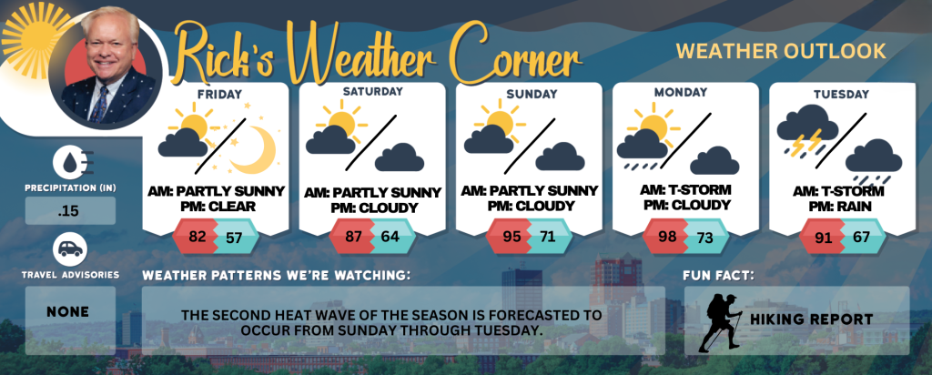
Friday (4th of July): Mostly sunny and nice. High 82 Winds: NW 10-15 mph
Friday night: Great viewing for fireworks. Mainly clear & cool. Low 57 Winds: NW 5-10 mph
Saturday: Comfortable with some sun & clouds. High 87 Winds: WSW 5-10 mph
Saturday night: Partly cloudy. Low 64 Winds: Light & Variable
Sunday: Some sun, hot, and more humid. High 95 (feel like 98) Winds: SW 10-15 mph
Sunday night: Partly cloudy, warm, and humid. Low 71 (feel like 73) Winds: SSW 5-10 mph
Monday: Predominantly sunny, muggy, and extremely hot, with isolated thunderstorms anticipated in the afternoon. High 98 (feel like 100) Winds: SW 5-15 mph
Monday night: Partly cloudy, warm, and muggy. Low 73 (feel like 76) Winds: Light & Variable
Tuesday: Hot & humid; a couple of thunderstorms in the afternoon. High 91 (feel like 97) Winds: WNW 5-10 mph
Tuesday night: Mostly cloudy and humid with some early showers. Low 67 (feel like 69) Winds: Light & Variable
Weather Patterns We’re Watching
The second heat wave of the season is forecasted to occur from Sunday through Tuesday.
Get Out!
Take a Hike: Take a Hike: Summits above 4,000 feet: Summits obscured. Highs in the upper 50s… except in the lower 50s at elevations above 5000 feet. Northwest winds 15 to 25 mph with gusts up to 55 mph. Elevations between 2,500 and 4,000 feet: Summits obscured. Highs in the lower 60s. Northwest winds 10 to 15 mph with gusts up to 40 mph
Hit the Beach Hampton & Rye Beach
Weather: Sunny.
UV Index: Very high.
Thunderstorm Potential: None.
High Temperature: In the lower 80s.
Winds: Northwest winds around 5 mph.
Surf Height: Around 2 feet, subsiding to around 1 foot in the afternoon.
Water Temperature: 63 degrees.
Rip Tide Current Risk: Low.
Tides Hampton Beach: High 7.3 feet (MLLW) 07:08 AM. Low 1.5 feet (MLLW) 01:25 PM.
SATURDAY: Surf height around 2 feet. Partly sunny. Highs in the upper 70s. Southwest winds around 5 mph.
SUNDAY: Surf height around 2 feet. Mostly sunny. Highs in the upper 80s. Southwest winds around 10 mph.
Jump in a Lake Weirs Beach: Northwest winds around 10 mph with gusts up to 25 mph. Waves around 2 feet building to 2 to 4 feet in the afternoon. Sunny. Not as warm with highs in the lower 70s. Thunderstorms are not forecast for this period. Water temperature 73 degrees.