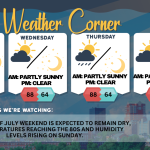
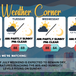
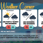
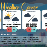
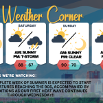
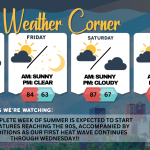
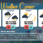
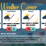
Tuesday’s weather: Humid, cloudy, high of 88 with T-storm possible in the p.m.

read more…: Tuesday’s weather: Humid, cloudy, high of 88 with T-storm possible in the p.m.

Today (July 1): Expect a cloudy day with high humidity, making it feel even warmer, around 95 degrees. Thunderstorms may be on the horizon, so be prepared for sudden changes in the weather. Some thunderstorms may be severe with gusty winds and heavy rainfall in the afternoon. The high will reach 88 degrees, with winds coming from the SSW at 5-15 mph.

Tuesday’s weather: Heat wave continues, high of 102 (feels like 107 with humidity)

read more…: Tuesday’s weather: Heat wave continues, high of 102 (feels like 107 with humidity)

The weather will be predominantly sunny, extremely hot, and muggy, with a chance of a stray shower or thunderstorm. Temperatures are expected to exceed the record high of 95 degrees set in 2013, reaching a high of 102 degrees, but feeling more like 107 due to humidity. It is advisable to take precautions if you plan on being outdoors for extended periods. Winds will be coming from the WNW at 5-15 mph.

Friday’s weather: Welcome summer, high of 84 – get ready for a heat wave, starting Sunday

read more…: Friday’s weather: Welcome summer, high of 84 – get ready for a heat wave, starting Sunday

Happy summer! New Hampshire is expected to experience an intense heat wave, marking the highest temperatures since last summer and potentially in several years, both duration and humidity levels. The first several days of summer will feature temperatures in the 90s, accompanied by muggy conditions and heat indices exceeding 100 degrees. Heat wave will run Sunday through Wednesday making it a four-day heat wave!!

Support Ink Link